- Not Search Found
Badrinath Yatra Road Route map with Distance and Directions
Planning your Badrinath Yatra road route? Every year, millions of pilgrims from across India set out for this sacred journey in the Garhwal Himalayas of Uttarakhand. But knowing the actual road distances, route conditions, and practical ground-level details can make the difference between a smooth Yatra and a stressful one.
In 2026, Badrinath Temple officially opens on April 23 at 6:00 AM, and online registration for the Char Dham Yatra started March 6, 2026. Whether you are travelling by road, train, or helicopter, here is everything you need.
Where is Badrinath Dham Located?
The holy Divya Desam of Badri Vishal sits at an elevation of 3,415 metres above sea level in the Chamoli district of Uttarakhand. It rests between the Nar and Narayan mountain peaks, directly beneath the mighty Nilkantha Parvat.
The temple stands on the banks of the Alaknanda river, which eventually joins the Ganga downstream. This sacred geography is what makes Badrinath not just a destination, but a spiritual experience that begins the moment you enter Uttarakhand.
Badrinath is the final stop on the Char Dham Yatra circuit, after Yamunotri, Gangotri, and Kedarnath. Trekkers also pass through here en route to Auli, Valley of Flowers, and Hemkund Sahib.
How to Reach Badrinath Dham
By Road
Road is the most popular way to reach Badrinath. The nearest airport is Jolly Grant Airport in Dehradun, approximately 301-317 km away. Most pilgrims hire a taxi or cab from here and drive through the scenic Garhwal valleys.
The Char Dham All-Weather Road Project (900 km total) is roughly 75% complete. Some sections between Nagarasu and Helang still have ongoing construction, so minor delays are possible during monsoon. Carry extra patience — and a buffer day in your itinerary.
By Train
Rishikesh Railway Station is the nearest to Badrinath, approximately 297 km away. Haridwar (about 324 km) has better train connections to major cities including Delhi, Mumbai, and Lucknow. From either station, local buses and private cabs head towards the yatra route.
By Helicopter
Helicopter is the fastest option and is ideal for senior citizens or those short on time. Services fly from Sahastradhara Helipad in Dehradun, covering the 300+ km road distance in just 50-60 minutes of flight. The Badrinath helipad is 1 km from the temple, and transport is provided.
Pricing for 2026: A round-trip all-inclusive package from Dehradun starts at approximately Rs. 86,200 per person (off-peak), rising to Rs. 89,900+ during peak May-June season. Weight limit is 75 kg; extra weight is charged at Rs. 2,500/kg. Max 6 passengers per helicopter.
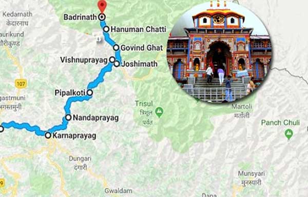
Badrinath Yatra Road Route Map with Distance
Route 1: Haridwar / Rishikesh to Badrinath (Main Route)
The most travelled route, passing through all five Prayags along the Alaknanda valley.
| Segment | Distance |
|---|---|
| Haridwar to Rishikesh | 24 km |
| Rishikesh to Devprayag | 71 km |
| Devprayag to Kirtinagar | 30 km |
| Kirtinagar to Srinagar (Garhwal) | 4 km |
| Srinagar to Rudraprayag | 34 km |
| Rudraprayag to Gauchar | 20 km |
| Gauchar to Karnaprayag | 12 km |
| Karnaprayag to Nandprayag | 20 km |
| Nandprayag to Chamoli | 11 km |
| Chamoli to Birahi | 8 km |
| Birahi to Pipalkoti | 9 km |
| Pipalkoti to Garur Ganga | 5 km |
| Garur Ganga to Helang | 15 km |
| Helang to Joshimath | 14 km |
| Joshimath to Vishnuprayag | 13 km |
| Vishnuprayag to Govindghat | 8 km |
| Govindghat to Pandukeshwar | 3 km |
| Pandukeshwar to Hanuman Chatti | 10 km |
| Hanuman Chatti to Badrinath | 11 km |
| TOTAL (Haridwar to Badrinath) | ~320 km |
Travel time: 10-12 hours by road. Most pilgrims break the journey with an overnight halt at Joshimath or Rudraprayag.
Route 2: Kedarnath to Badrinath via Chopta
Scenic route for pilgrims who have already visited Kedarnath, passing through Chopta — often called the Mini Switzerland of Uttarakhand.
| Segment | Distance |
|---|---|
| Guptkashi to Ukhimath | 20 km |
| Ukhimath to Dugalbitta | 22 km |
| Dugalbitta to Chopta | 7 km |
| Chopta to Mandal | 27 km |
| Mandal to Gopeshwar | 8 km |
| Gopeshwar to Chamoli | 10 km |
| Chamoli to Badrinath | 96 km |
| TOTAL | ~190 km |
Route 3: Kedarnath to Badrinath (Direct Road Route)
The standard connecting route between Kedarnath and Badrinath, following the Alaknanda valley via Rudraprayag.
| Segment | Distance |
|---|---|
| Kedarnath to Gaurikund | 14 km |
| Gaurikund to Sonprayag | 8 km |
| Sonprayag to Rampur | 5 km |
| Rampur to Phata | 9 km |
| Phata to Guptkashi | 14 km |
| Guptkashi to Kund | 7 km |
| Kund to Augustmuni | 19 km |
| Augustmuni to Tilwara | 9 km |
| Tilwara to Rudraprayag | 8 km |
| Rudraprayag to Karnaprayag | 32 km |
| Karnaprayag to Chamoli | 39 km |
| Chamoli to Joshimath | 36 km |
| Joshimath to Vishnuprayag | 13 km |
| Vishnuprayag to Govindghat | 8 km |
| Govindghat to Pandukeshwar | 3 km |
| Pandukeshwar to Hanuman Chatti | 10 km |
| Hanuman Chatti to Badrinath | 11 km |
| TOTAL | ~245 km |
Best Time to Visit Badrinath
| Period | Weather | Crowds | Best For |
|---|---|---|---|
| Late April – Mid May | Cold, possible snow on peaks | Moderate (post-opening rush) | Spiritual atmosphere, early darshan |
| June | Pleasant, clear skies | Very heavy (school holidays) | Weather, but book accommodation early |
| July – August | Monsoon, landslide risk | Moderate | Risky roads; need buffer days |
| September | Clear skies, cool | Low to moderate | Best overall — calm, clear, comfortable |
| October (pre-closure) | Cold returning | Low | Devotional pre-winter atmosphere |
What most experienced yatris will tell you: September is the sweet spot. Clear skies, no monsoon disruptions, and far fewer crowds than June. If you are visiting with elderly family, this is the window to plan for.
Practical Travel Tips for Badrinath Yatra
- Register early at registrationandtouristcare.uk.gov.in — daily caps fill fast in May and June.
- Carry warm clothes regardless of month. Early morning Darshan at 4:30 AM near 3,400 metres is cold even in May.
- Plan an overnight halt at Joshimath (1,890 m) before ascending to Badrinath (3,415 m). One night of acclimatization helps significantly.
- Book accommodation in Badrinath town at least 2-3 weeks in advance during peak season.
- Keep basic medicines: altitude sickness tablets (on doctor's advice), headache relief, ORS sachets, and antacids.
- For helicopter travel: reach Sahastradhara Helipad by 6:00 AM. Flights are weather-dependent — carry your hotel contact and have a backup plan.
- Check road and weather updates before departure, especially in July-August. BRO and SDRF contacts should be saved on your phone.
Common Mistakes to Avoid
- Skipping registration: Government checkpoints at Barkot, Sonprayag, and other entry points will turn you back without a valid Yatra Registration Letter.
- Underestimating travel time: 320 km on mountain roads takes 10-12 hours, not 6-7 like on a national highway. Factor this into your itinerary.
- Ignoring monsoon risks: July-August landslides can close roads for 12-24 hours. Always keep a buffer day in your plan.
- Rushing through Badrinath: Beyond the temple, Tapt Kund (natural hot spring), Mana Village (last Indian village before Tibet border), Bhim Pul, and Vyas Cave deserve at least a full day.
- Not checking body weight before helicopter booking: The 75 kg weight limit is strictly enforced; exceeding it costs Rs. 2,500 per extra kg.
Safety Tips for High-Altitude Travel
- Get a medical check-up before travel, especially if you have blood pressure, diabetes, or respiratory conditions.
- Stay hydrated: drink 3-4 litres of water daily at altitude.
- Avoid alcohol and smoking — both worsen altitude sickness.
- Walk slowly after arrival and avoid sudden physical exertion.
- In 2026, the Uttarakhand government has deployed helicopter and boat ambulances for emergency medical support along the route.
Frequently Asked Questions
When does Badrinath open in 2026?
Badrinath Temple opens on April 23, 2026 at 6:00 AM, officially confirmed by the Badrinath-Kedarnath Temple Committee (BKTC).
Is Char Dham registration mandatory in 2026?
Yes. Registration is free and mandatory for all pilgrims. It started March 6, 2026. Register at registrationandtouristcare.uk.gov.in or via the Tourist Care Uttarakhand app.
What is the distance from Haridwar to Badrinath?
Approximately 320 km by road. Journey time is 10-12 hours depending on traffic and road conditions.
Which is the best route from Haridwar to Badrinath?
Route 1 via Rishikesh, Devprayag, Rudraprayag, and Joshimath is the most used and best-maintained road. Follow NH 7 (Rishikesh-Badrinath Highway) for the cleanest drive.
Is Badrinath safe for elderly pilgrims?
Yes. No trekking is required — the temple is directly accessible by road. For those with health concerns, the helicopter service from Dehradun is the safest and most comfortable option.
What is the best time for Badrinath Yatra in 2026?
September offers the best experience: clear skies, low crowds, and pleasant temperatures. May-June is also good weather-wise but significantly more crowded.
Badrinath Overview
Area
Geo Location
Elevation
State
District
Language
Best Time to Visit
Pin Code
STD Code
3 km² (approx)
Garhwal Himalayas
3,415 meter
Uttarakhand
Chamoli
Hindi, Garhwali
April to November
246422
01381