Last Updated on March 3, 2026
The Char Dham Yatra is one of the most sacred pilgrimages in Hinduism. Every year, lakhs of devout pilgrims from across India and the world make their way to four ancient temples nestled in the Himalayas — Kedarnath, Badrinath, Gangotri, and Yamunotri. Gracing the banks of holy rivers like Mandakini, Alaknanda, Ganga, and Yamuna, this journey is believed to grant moksha — liberation from the cycle of birth and death.
But let’s be honest — this yatra is so much more than a spiritual checklist. The roads, the mountains, the chai stops, the fellow pilgrims — it’s an experience you can only understand by doing it yourself.
That said, being well prepared starts with one thing: knowing the Char Dham Yatra route map in complete detail. That’s exactly what this guide covers.

Char Dham Yatra Route Map Distances
The Char Dham Yatra is one of the most sacred pilgrimages in Hinduism. Every year, lakhs of devout pilgrims from across India and the world make their way to four ancient temples nestled in the Himalayas — Kedarnath, Badrinath, Gangotri, and Yamunotri. Gracing the banks of holy rivers like Mandakini, Alaknanda, Ganga, and Yamuna, this journey is believed to grant moksha — liberation from the cycle of birth and death.
But let’s be honest — this yatra is so much more than a spiritual checklist. The roads, the mountains, the chai stops, the fellow pilgrims — it’s an experience you can only understand by doing it yourself.
That said, being well prepared starts with one thing: knowing the Char Dham Yatra route map in complete detail. That’s exactly what this guide covers.
Important: Registration is Now Mandatory
Before we get into routes and distances, here’s something you cannot skip in 2026.
The Uttarakhand government has made biometric registration compulsory for all Char Dham pilgrims. Registration is free and can be done:
- Online: registrationandtouristcare.uk.gov.in
- Mobile App: Tourist Care Uttarakhand
- WhatsApp: Send “Yatra” to +91-8394833833
- Offline: At centers in Haridwar, Rishikesh, Barkot, Uttarkashi, Sonprayag, Joshimath
After registration you get a Yatra Registration Letter with QR code — scanned at every temple entry. Without this, entry is not allowed.
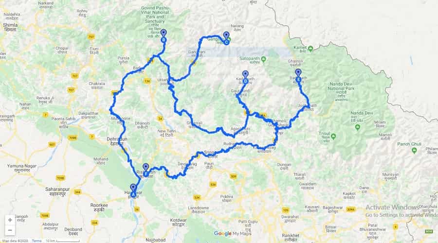
Location of the Four Char Dham Temples
All four temples are in remote, high-altitude locations in Uttarakhand. Thanks to the Char Dham Mahamarg Vikas Pariyojana project, roads have improved significantly. Here are the distances:
| Temple |
Distance from Rishikesh |
| Yamunotri Temple |
~232 km |
| Gangotri Temple |
~259 km |
| Kedarnath Temple |
~205 km (up to Gaurikund) |
| Badrinath Temple |
~298 km |
The full Char Dham circuit from Haridwar covers approximately 1,607 km in total.
Char Dham Route from Delhi – Step by Step
| Leg |
Distance |
| Delhi to Haridwar |
~210 km |
| Haridwar to Barkot |
~220 km |
| Barkot to Yamunotri (Janki Chatti) |
~36 km + 6 km trek |
| Yamunotri to Uttarkashi |
~125 km |
| Uttarkashi to Gangotri |
~100 km |
| Gangotri to Rudraprayag |
~180 km |
| Rudraprayag to Kedarnath (Gaurikund) |
~74 km + 16–18 km trek |
| Gaurikund to Badrinath |
~160 km |
| Badrinath to Rishikesh |
~297 km |
| Rishikesh to Delhi |
~230 km |
The traditional sequence — Yamunotri → Gangotri → Kedarnath → Badrinath — is considered spiritually correct, moving from west to east.
Route Map of Kedarnath
Kedarnath is by far the toughest Dham. Sitting at 3,583 meters, it requires trekking no matter how you arrive at Gaurikund. Planning here is non-negotiable.
By Road: Drive or hire a cab from Haridwar, Rishikesh, or Delhi up to Gaurikund — the last motorable point. From there, a 16–18 km trek leads to the temple. The route passes through Devprayag, Rudraprayag, Guptkashi, and Phata. Buses also ply regularly from Rishikesh to Gaurikund.
By Railway: Nearest stations are Rishikesh (241 km) and Haridwar (215 km), both well-connected to major cities. Dehradun is 257 km away but has limited train connectivity. Cabs and shared taxis are easily available from all three.
By Helicopter: Helipads at Sersi, Phata, Sitapur, and Guptkashi operate services from Dehradun’s Sahastradhara helipad during peak season. Slots fill up fast — book early. Note that even helicopter pilgrims must complete yatra registration.
Route Map of Badrinath
Badrinath is the easiest Dham to reach. The temple sits right off the main road in Chamoli district, on the banks of the Alaknanda River at 3,133 meters. No major trek required.
By Road: Cabs, private cars, and buses run from Haridwar and Rishikesh. The route passes through Devprayag, Karanprayag, Joshimath, and Hanumanchatti. Distance from Rishikesh is ~298 km, approximately 8 hours by road.
By Railway: Rishikesh and Haridwar are the nearest stations, well-connected to the national rail network from all parts of India.
By Helicopter: Services depart from Sahastradhara helipad in Dehradun. The Badrinath helipad is just 1 km from the temple entrance — the most convenient helicopter drop in the entire circuit.
Route Map of Gangotri
Gangotri is the abode of Goddess Ganga — the point where the holy river is said to have first touched earth from heaven. The temple sits at 3,200 meters in Uttarkashi district.
By Road: From Haridwar, Rishikesh, or Dehradun, the road journey to Gangotri covers ~259 km from Rishikesh (around 7 hours). The route passes through Chamba, Uttarkashi, and Harsil. Roads are generally smooth, though monsoon brings landslide risks between July–August.
By Railway: Trains to Rishikesh, Haridwar, or Dehradun serve as the gateway. All three are connected to major cities across India.
By Helicopter: Private operators run helicopter services for Gangotri. Unlike Badrinath, the helipad here requires a short additional road transfer before reaching the main temple.
Route Map of Yamunotri
Yamunotri is the traditional starting point of the Char Dham sequence. The temple is dedicated to Goddess Yamuna and sits at 3,293 meters in the Rawai Valley. Be ready to walk — the final stretch is on foot.
By Road: From Haridwar or Rishikesh, the road leads to Janki Chatti — the last motorable point. From there, a 6 km trek takes you to the temple. Palki and pony services are available for those who need them. Two road routes are available: via Dehradun → Vikas Nagar → Barkot, or via Chamba → Uttarkashi → Barkot.
By Railway: Rishikesh and Haridwar are the main rail gateways, with train services running from across the country.
By Helicopter: The nearest helipad is at Kharsali village, close to Janki Chatti. From Kharsali, local transport brings pilgrims to the trek base, and the rest is on foot.
Best Time for Char Dham Yatra
The temples open every year around April–May (Akshaya Tritiya) and close in October–November (Diwali season). Exact dates are announced by the respective temple committees each year.
| Season |
Months |
Experience |
| Peak Season |
May – June |
Best weather, most crowded |
| Post-Monsoon |
September – October |
Clear skies, fewer crowds — recommended |
| Monsoon |
July – August |
Risky — landslides and road closures likely |
From real experience — if you want peaceful darshan without the massive queues, September and early October are the sweet spot.
Practical Travel Tips
- Register in advance — don’t wait until you reach Rishikesh
- Start driving early each day — mountain roads get congested and visibility drops by afternoon
- Carry warm clothing even in May — temperatures near Kedarnath drop close to freezing at night
- Avoid monsoon travel unless your itinerary is fully flexible
- Keep both a physical and digital copy of your registration letter
- Stay hydrated and eat light, especially while trekking at altitude
- A full road-based yatra takes 10–12 days; helicopter packages can finish it in 2–3 days
- Personal cars are permitted on all Char Dham roads, but mountain driving experience is strongly recommended
Frequently Asked Questions
Q-1: Is Char Dham Yatra registration free?
Ans: Yes, completely free via the official Uttarakhand government portal.
Q-2: Can I visit without registration?
Ans: No. Entry to all four temples requires a valid QR code or printed yatra registration letter.
Q-3: Which Dham is the hardest to reach?
Ans: Kedarnath — due to the 16–18 km steep high-altitude trek from Gaurikund.
Q-14: What is the total distance of the full yatra?
Ans: Approximately 1,607 km by road from Haridwar for the complete circuit.
Q-5: Can elderly pilgrims do this yatra?
Ans: Yes — palki, pony, and helicopter options are available for all four Dhams. Consulting a doctor before travel is recommended, especially for Kedarnath.
Q-6: What documents are needed for registration?
Ans: A valid photo ID (Aadhaar, Voter ID, Passport, or Driving License), passport-size photo, and mobile number. A medical fitness certificate is strongly advised for Kedarnath.